
Site Scan for ArcGIS
Site Scan for ArcGIS is the end-to-end cloud-based drone mapping software designed to revolutionize imagery collection, processing and analysis. Maintain a complete picture of your drone inventory and flight history with automatic fleet management. Stay up-to-date with accurate imagery when needed with repeatable flight plans that ensure high quality data capture when flying your drones. Securely process imagery in a scalable cloud environment to create high-quality 2D and 3D imagery products that can be quickly shared throughout your organization on any device. Save time by using the measurement and analysis tools to get the answers you need from your data.
Directly publish your drone data to your ArcGIS organization to perform advanced drone analytics such as object detection and application of artificial intelligence (AI).
Complete drone mapping software in the cloud
Plan autonomous drone flights in 3D
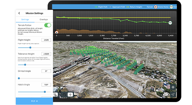 Increase efficiency by creating and sharing advanced 3D flight plans with your pilots. Overlay 2D and 3D data from ArcGIS Online and ArcGIS Enterprise for enhanced flight safety and data quality. Manage your data in the field and upload it to the cloud.
Process and analyze in the cloud
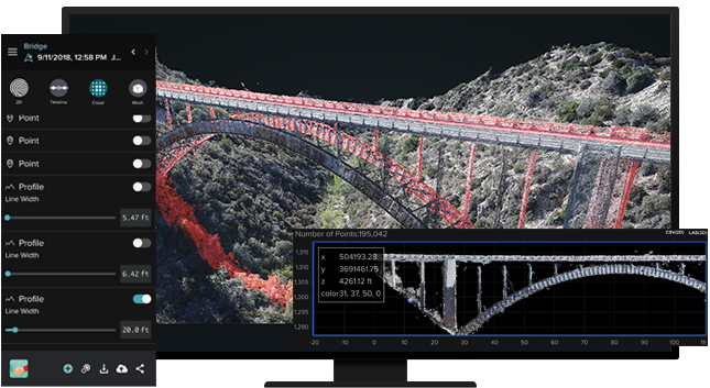 Unlimited amounts of drone flight data are processed into 2D and 3D outputs through a scalable cloud environment. High accuracy is ensured through automatic ground control point detection. Easily visualize and analyze results directly in a web browser.
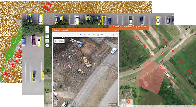
Drone analytics
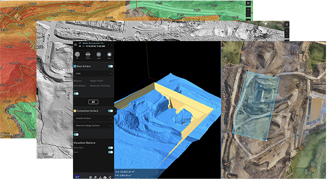 Perform drone analytics by measuring distances, surface areas, and volumetrics; conducting temporal analysis; generating cut/fill maps; and measuring change over time. Maintain quality control by comparing your drone data to design overlays—including those in your Autodesk cloud environment—or compare it to drone data captured earlier in the project.
Quickly share drone and project data
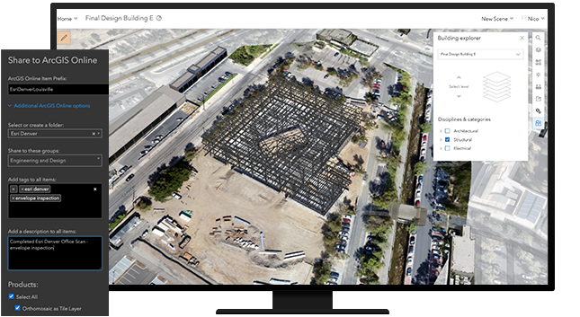 Share information with your stakeholders in formats they understand, whether in a 3D view, as a report, or as a map within ArcGIS Online or ArcGIS Enterprise; invite read-only users to analyze data in Site Scan Manager for ArcGIS; share content and report issues within Autodesk BIM 360; or export in common file formats.
Enterprise fleet management
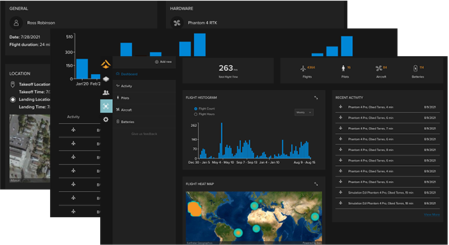 Fleet management keeps track of flights, drone hardware, and pilot flight history—all in one place. Drone program managers can create custom preflight checklists for their teams and store responses in the cloud.
Advanced data analysis in ArcGIS
 With the press of a button, Site Scan aerial photogrammetry data is available throughout the ArcGIS system, on-premises or in the cloud, to perform and automate advanced analytics such as object detection with ArcGIS Image Analyst. Easily integrate your drone imagery with building information modeling (BIM), lidar data, real-time Internet of Things (IoT) data, and more.
How it works

Plan
Plan the optimal flight path. For enhanced safety and planning accuracy, import layers and 3D models from previous flights or ArcGIS Online.
Execute autonomous flight
Complete your preflight checklist and execute an autonomous drone flight.
Upload and process in the cloud
After the flight is complete, upload your data for cloud processing and mark ground control points manually or automatically using computer vision.
Visualise and analyse
View 2D and 3D outputs on the web. Discover insights about your project, track changes, measure volumes, and conduct inspections or other analyses.
Share results
Export in file formats you need, publish to your ArcGIS organisation for advanced analysis, or export to Autodesk BIM 360.
What does Site Scan for ArcGIS do?
Site Scan for ArcGIS provides drone flight planning, fleet management, image processing, and analysis capabilities as Software as a Service (SaaS). Site Scan delivers a complete end-to-end solution for drone imaging projects.
With Site Scan, drone operators can:
- Plan and execute drone flights and manage flight data and metadata to support project requirements
- Manage their drone fleet to run safe and efficient drone operations
- Generate 2D and 3D mapping and analytics products from drone imagery
- Publish drone mapping products to ArcGIS Online, ArcGIS Enterprise, and Autodesk BIM 360
Is Site Scan for ArcGIS an app, an ArcGIS Desktop extension, or something else?
Site Scan for ArcGIS consists of two applications:
- Site Scan Flight Planning is a flight planning and control application for drone operators that runs on iOS (iPad). The app is integrated with the ArcGIS platform and allows users to plan automated flights in 2D or 3D, and allows the user to control the drone in flight.
- Site Scan Manager is a web-based application for processing, managing, and performing analysis on drone imagery. The app also includes an administrative dashboard for managing users and project permissions, available to users with administrator privileges.
How do Site Scan for ArcGIS licenses work?
There are currently three license types:
- Viewer license: These users can see project data in Site Scan Manager and use the measurement tools, but can’t make any edits or changes.
- Access license: These users can use the full functionality of Site Scan Manager in their assigned projects, including creating and persisting measurements, processing existing data and downloading processed outputs. They can also create a drone flight plan in Site Scan Manager, but aren’t able to fly a drone with Site Scan Flight Planning. Administrator functions, such as User Management and Fleet Management, require this license type.
- Operator license: In addition to the capabilities of an Access license, these users are able to fly a drone using Site Scan Flight Planning and upload images for processing.
Which drones are supported in Site Scan Flight Planning?
- DJI Matrice 200 series
- DJI Matrice 200 V2 series
- DJI Inspire 2
- DJI Mavic Pro
- DJI Mavic 2 Pro
- DJI Phantom 4 Pro
- DJI Phantom 4 Pro V2
- DJI Phantom 4 RTK (with SDK controller)
Two additional drones are supported with “Beta mode” enabled (no testing conducted on these aircraft at this time): DJI Phantom 4 Advanced and Mavic Pro.
If you use an unsupported drone, you won’t be able to capture data with Site Scan Flight Planning, but you will be able to process images using Site Scan Manager if the raw photos have GPS metadata tagged in the EXIF.
What types of imagery can I process with Site Scan Manager?
Images must be geotagged JPEG files. You can process thermal and multispectral imagery. Video cannot be processed into maps and models, but can be used in conjunction with geospatial video logs recorded on the flight planning app to be used with FMV tools in ArcMap and ArcGIS Pro.
How accurate are the data outputs?
Using ground control points (GCPs), accuracy of 1 cm/ 0.2 inches or better can be achieved vertically and horizontally. Accuracy can be validated using the “Checkpoint” Site Scan feature.
How can I access and share the resulting imagery products?
The output data products from a drone flight (the orthomosaic, DTM, DSM, point cloud, and textured mesh) are stored in the cloud, and can be viewed in Site Scan Manager. They can also be published to ArcGIS Online and shared within your organization or with the public.
Site Scan for ArcGIS Pricing
| Units | Description | 12 MONTHS |
|---|---|---|
| Operator License | Site Scan for ArcGIS | $5,000 |


